
About the makers

The Development Team

A travel guide, made in Geneva

Nestour GPS came from the road: knowing what is worth the detour without reading a guide at every stop, keeping a realistic day around the driving, and remembering the trip afterwards.

There is no account, and nothing about you or your trips goes to a Nestour server. Your plans, trips and logbook stay on your device.

The rule is simple: a tier, an area and a duration, then paid add-ons, unlocked by a licence that is checked offline on your own device.
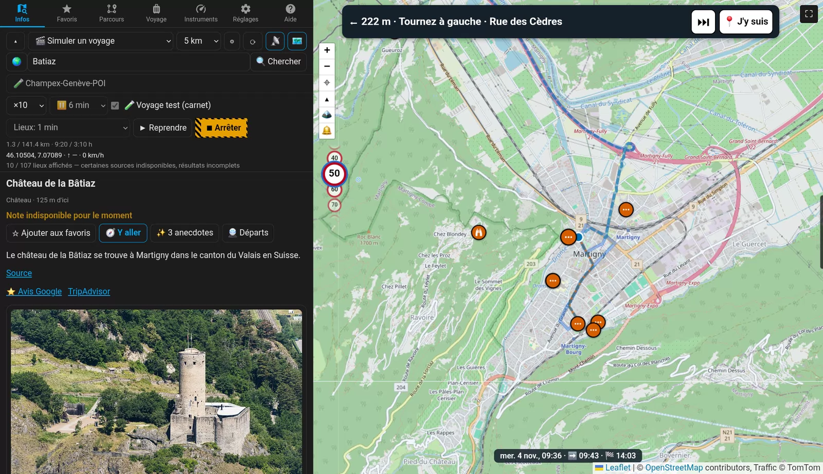
Nestour GPS: La Bâtiaz above Martigny, its card and photo

Where things stand

  • Today

    Nestour GPS 0.15.0 is in free beta, on Android, Windows and Linux.

  • 5 November 2026

    Nestour GPS 0.14 and 0.15: the beta edition and its personal key, light or dark, feedback from inside the app.

  • November 2026

    Nestour GPS 0.13: lanes and exit signs, automatic zoom, Mapy.com and IGN hiking maps, descriptions translated by your AI, Linux.

  • October 2026

    Nestour GPS 0.11: 3D relief map, trip computer, turn by turn spoken in your language.

  • 28 February 2027

    The free beta ends; licences start.

Release notes

Everything Nestour GPS learned, newest first, from the first line of code on 24 October 2026. 🆕 marks the latest release. In short here; every version in detail.

🆕 0.14.0 → 0.15.0 · 5 November 2026

  • 🆕 The beta key: the beta now needs your personal key, checked on the device without going online, good until 28 February 2027. Without it the app is a simple GPS: the standard map, your position, the instruments, speed signs, recording a trip, and your data (0.15.0).
  • 🆕 The beta edition: 10 trips, 10 routes, 10 plans and 25 favourites; at a limit the app offers to remove the oldest and never deletes anything on its own. App languages: English, French, Chinese and Finnish. Export keys file waits for a licence; Import stays (0.14.0).
  • 🆕 Light or dark, Help → Send feedback with the version filled in, a daily check for new versions (only the version number goes along, and you can turn it off), and clearer lists for routes, plans and trips (0.14.0).

0.13.1 → 0.13.3 · 5 November 2026

  • Export keys file: hand this device's keys to your other phones and tablets (0.13.3; with a licence since 0.14).
  • Automatic zoom: off, by speed, or Smart: close up in town, the whole search radius on the motorway, zooming in before a junction or a stop (0.13.2).
  • Lanes and exit signs in the turn-by-turn banner, one arrow per lane, signs in the country's motorway colours (0.13.2).
  • Descriptions in your language more often: the place's own language comes before English, and your AI translates it (0.13.1).

0.13.0 · 2 November 2026

  • Linux: an AppImage for Arch, Omarchy and other x86_64 distributions.
  • Hiking and winter maps: Mapy.com (trails, ski runs, huts) and France's IGN SCAN 25.
  • Speed signs that follow your route, from TomTom, right even when OpenStreetMap is down.
  • Your own map search server, a monthly data limit in money, show or hide each instrument, the phone's address book and Nextcloud contacts, TomTom as a route choice, simulation at ×1 and ×5.

0.12.0 → 0.12.6 · 1–2 November 2026

  • Spoken guidance with a voice button on the map: off, beeps, spoken.
  • The speed sign wheel: 3, 4 or 6 signs that turn with the limit; a sudden 30 from a side road is held back on the motorway.
  • Preview the route in the app: distance, time with traffic, fuel and its cost.
  • 🚆 Departures near a place in Switzerland; French and Spanish IGN maps.
  • From the car: type in your odometer and dashboard figures and the trip computer counts on from there.
  • 📍 I'm here inside car parks, arrival times on the map, button sizes S to XL, a 12 h clock, Share this trip, routes and trips by city, no U-turn when you leave a car park.

0.11.0 → 0.11.3 · 31 October 2026

  • 🏔 3D map (experimental): the mountains stand up, with your route and places on them.
  • By place: routes, plans, past trips and favourites by country and region.
  • The way back: start any route or trip in reverse. Skip a waypoint in one tap, with Undo.
  • Google reviews and TripAdvisor links, place types in your language, Simple and All setup, colour-blind traffic, logbook PDF covers.

0.10.0 → 0.10.5 · 30–31 October 2026

  • Trip computer: since departure, since reset, consumption and range.
  • Heading up map, map tiles kept for offline use, photos in the logbook PDF.

0.9.0 → 0.9.5 · 29–30 October 2026

  • The app gets its name, Nestour GPS, and its icon.
  • Voice, vehicles, and an automatic travel mode.
  • Your own AI, several side by side; swisstopo maps.
  • Postcards, a data budget, visits up to 10 hours and free time in a plan.

0.5.0 → 0.8.8 · 28–29 October 2026

  • Turn by turn (0.7.0) and 67 app languages (0.7.1).
  • Trip plans with a timetable: leave at or arrive by, nights, live TomTom traffic, Waze and TomTom GO hand-off (0.8).
  • The full logbook (0.5.0) with End of day and Start day, and a PDF.
  • The 🛰 Instruments tab, seven languages and metric or imperial units (0.6.0), import of a keys file, Swiss motorway limits and tunnel signs.

0.1 → 0.4 · 26–27 October 2026

  • Nestour becomes an app: a standalone app for Android and Windows, with on-device search, descriptions and geocoding.
  • Android background GPS and notifications, activity recognition, record a trip, travel modes.
  • Speed signs with a beep and a road log, costs and weather, map skins, colour-blind schemes.
  • The 🎬 trip simulator, the full-screen map, keys and AI in Setup, Google contacts, place icons.

The beginning · 24–25 October 2026

  • Nestour starts as a card for Home Assistant: the places worth a stop around you, with stars.
  • Go, Setup, country and city search, the Trip tab, a logbook to Google or Nextcloud, ViaMichelin routes.
  • GPS dials, descriptions in 63 languages with AI translation, waypoints by tapping the map, long routes in stretches, contacts, what3words.

Try before you buy

Nestour GPS is free in beta until 28 February 2027.

To the shop